Last Saturday, a small group of us rode Quietway 1 from Waterloo to Greenwich. I think it's fair to say that the cycling infrastructure was variable, but overall it is a potentially useful route which has some unfinished business. A special thanks to Lewisham Cyclists for joining us and giving some useful local insight.
So, Quietway 1 is headlined as a route between Waterloo Station and Greenwich town centre. I must admit I knew some of the route as I had cycled a section between Borough and Bermondsey a few years ago with Sustrans London and more recently with them a few months before Q1 was opened. I was therefore intersted to see how it had all turned out.The route spans four boroughs; Lambeth, Southwark, Lewisham and Greenwich and I'll say it now; this is the reason the route is variable, together with the route trying to avoid main roads. Sustrans is involved as Transport for London's delivery agent for the Quietways programme and in some cases is helping with design work; and in others making sure they are delivered in accordance with what TfL expects to see; but do not be under any illusion, the decisions lie with the boroughs and it seems the four have made slightly different decisions with Greenwhich deciding to do pretty much nothing. TfL is involved in some places where its roads are crossed and they deal with traffic signals across London. I did feel cheated in places as the route obliterates some perfectly good old London Cycle Network routes and I feel that Q1 should have been in addition to them.
On the whole, I would say the route doesn't quite know what it is. It can be used for commuting, but the A roads will be quicker; it can certainly be used for local trips; and it certainly can be used for leisure. With local trips, its largely away from main roads where the shops and services are; and in some cases, the route choices seem a little strange. But, there is still much to praise.
So, using plenty of photos, let's follow the route from the Waterloo end.

This is Upper Ground which runs along part of the south bank of the Thames; behind the London Eye, the South Bank Theatre and the National Theatre to name a few attractions. It's also the place to access Waterloo Station, but it took us a while the find the signage which is terrible. The road surface is utterly shot and there is far too much traffic, even on a Saturday and we had to mix with taxis, coaches and plenty of private cars.

This is Cornwall Road, the site of a pretty old bollarded traffic filter with the cycle bypasses bizarrely on one side of the road. This needs to be changed to a central bollard so people can intuitively pass. Note the excellent cafe on the left which I had breakfast in the other week as I watched the weekday rush hour go by; the place was dominated by people walking and cycling with the area simply motor vehicle access and quiet from what I could make out.

Here, the route crosses The Cut into Webber Street which is filtered (you can see the cycle bypass ahead. There were signs of failure on the expensive stone surfacing - I really think we should stick to asphalt.

Here Webber Street has passed into Southwark and we approached Blackfriars Road which has the excellent CS6 running north-south. You can see a sign explaining how to get onto CS6 and then above, another sign with the Quietway branding. It's clear both were being looked at separately as a single unified sign would have been so much clearer.

Still in Webber Street, we have a brand new and expensively paved humped zebra crossing. I like humped zebra crossings as it is easier to cross on a level surface. The planting to the left is nice, but it will block the view of people crossing. Southwark seems to have spent a lot on making the street pretty, but there is no specific cycling provision. The street is not filtered and my guess is at peak times, it's going to be too busy.

At the end of Webber Street, it's a right turn onto Great Suffolk Street (again, I reckon it will be a busy road during the week).

We carried on across Southwark Bridge Road (which carries the paint'n'signs CS7). The low level cycle signal was welcome, but this junction has no early start for cycles. Some junctions on Q1 did, but it was inconsistently applied. Great Suffolk Street crosses Borough High Street (yes, we're avoiding shops again) to become Trinity Street which is filtered. However, as the next four photos show, the filter is a nightmare!


Yes, it's an utter disaster. The gates have been here for years and apparently the residents like them as they stop mopeds using the road. The wider estate it filtered and one can use a couple of other roads to bypass this tangle of steel, at the end has another filter which is useful for cycling, so why send people out of their way so more. Apparently Southwark have a plan to use camera enforcement to allow the barriers to be opened up and in my opinion it can't come soon enough.

A quick left after the barriers took us into Globe Street which ends in a signalised crossing of Great Dover Street. Again, it's an old feature which has lots on money spent on it; nice enough, but was it needed? The crossing goes into Pilgrimage Street which is also filtered and then into Tabard Street. My photo didn't come out, but Tabard Street is one way and has a kerb-protected contraflow cycle track which did seem weird given how quiet it was in yet another nicely filtered estate.

The route then goes along Law Street where one can find a nice little bidirectional cycle track connecting to Rothsay Street.

At the end of Rothsay Street, we have another nice little filter creating a signalised parallel crossing. By that I mean cycles have their own crossing (within the square "elephant's feet" markings) and just next to it (to the right in this direction) pedestrians have a PedX crossing. (PedX is the replacement for the Pelican and doesn't have a a flashing amber to traffic/ green to pedestrians). The problem here is the cycle crossing ends up on a bit of shared-use footway and you have to joggle back into the carriageway of Webb Street.

Looking back the other way, one has to use a narrow contraflow lane to get onto the footway to use the crossing as Webb Street is one way in from the main road (Tower Bridge Road). I saw this location before this layout was put in and it is leaps and bounds better than it was. Rothsay Street and Webb Street were not filtered. What needs to happen is the estate leading from Webb Street needs to be rethought so it can be closed to motors and a diagonal cycle crossing provded. Apparently the presence of a school on Webb Street means it can't be reworked as parents in cars need to be easily got into and out of the estate.

Still further on, we reach Willow Walk. There are speed humps here which suggests a rat-running and/ or speeding problem. At the end of Willow Walk, there is a right, then left movement through a recently signalised junction into Lynton Road. This is an issue as there is no early start signal and if one is on the nearside, one is at risk of a left hook. Again, filtering is needed here. Next it's right into Chaucer Drive and into a series of cul-de-sacs for motors which are connected with little bidirectional cycle tracks. The next five photos show this wonderful example of how to make a whole area of residential streets access for motors and through routes for cycling and walking.


This is an old route, but it has been upgraded really well. The second photograph up shows a curious double speed hump which is there to slow moped riders down and is perhaps a pragmatic acceptance that the route will be used by them. I saw a pizza delivery rider use the route when I rode it some months back and they did so gently, so is it a real issue? I do have two criticisms and that is there were way to many bollards and the upright signs were too small and not frequent enough (an issue generally we found as it is nice to know one is definitely still on the route!)

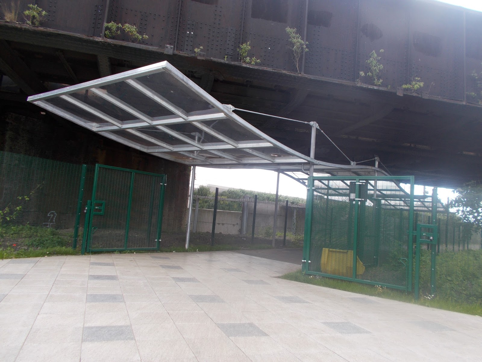
At the end of the wonderfully filtered estate, we reached a bridge over the Rotherhythe New Road. Until recently, this was a bridge to nowhere; it got you to South Bermondsey Station, but that was it. Now, a new greenway link has been threaded through the web of railway lines in the area with views of the The Den (Millwall Football Club). The link runs through Network Rail land and to be able to deal with that organisation takes a special kind of determination! One issue with the link is that it gets shut when Millwall plays at home (management of the crowds) and the diversion wasn't clear. But, this link has unlocked a huge area for access by foot and cycle.
The track was smooth and reasonably wide, but shared-use. I think some people might find the route a bit lonely, despite the lighting and this shows the downsides where a track isn't directly overlooked and fenced in; the social safety tends to suffer. The next six photos give a flavour.


The route is reasonably wide, it's lit and the surface is smooth. It is one of the highlights of Q1 and all credit to Sustrans for making it happen with Network Rail and the football club. At the end of the link, we entered Lewisham via Senegal Road (above). The route carries on along Surrey Canal Road (after a very tight left turn under the railway). The next three photos show the shared-use cycle track which is set well back from the road.


This was already a shared-use cycle rack, but it has been widened and a light coloured surface added which was fairly smooth to cycle on. The colour was an applied fine chipping (probably anti-skid) and I wonder if some machine-laid red asphalt might have been a better choice. The private accesses and side roads are a let down as cycles give way, but are also given a suggested priority by the unlawful use of elephant's feet which are reserved for controlled crossings.

The shared route continues across Surrey Cabal Road into Trundley's Road via a ahred-use refuge. Some of the local cycling group members wanted this crossing signalised, but apparently TfL wouldn't allow it because of the impact on (motor) traffic flow undert the adjacent low bridge. I wondered if as cycle zebra on a hump might have been the answer. The refuge is fine for standard cycles, but not wide enough for trailers. I have been told that the road here is very busy with industrial traffic and so we have the tension of trying to thread a route when an area-wide solution is needed. The crossing took us into Folkstone Gardens as shown on the next three photographs.


The wayfinding was a bit poor - the top of the three photos should have had an arrow to the right rather than ahead and there were no upright signs. Again, trying to thread routes through backstreets gets let down by having to wayfind non-intuitive movement.

The gardens took us under another railway bridge (this is South London after all!) and into Childers Street. The link from the park to the end of Childers Street is a lovely little treatment. It serves a couple of private accesses, but is there for walking and cycling. It is all flush, but there is visual contrast between space for walking and space for cycling; and it replaces a really awful cobbled surface, although again, the link under the bridge already existed.
The sign at the end of the link was much better than most we had seen. IT was of a decent size so one could make a decision on which way to turn and it wasn't fiddly finger posts which end up pointing the wrong way; I also like the additional of "Deptford" as it helps you know you've arrived somewhere. The right turn is into Childers Street which was LCN2 from what I can work out and again, it seems the old LCN is being obliterated which is going to leave us with random sections of routes which no longer join up.
Childers Street is another awful rat-run even on a Saturday morning and again, the wider area needs to be reviewed for filtering. Childers Street gives way to Clyde Street, the first part of which is through a little park. The next three photos show this. The dropped kerb to get from Childers Street into the park was too high (first photo) and again, the wayfinding was too minimal at the end (third photo). I know signs aren't an urban designer's favourite thing, but they are needed.


At the end of the park was a level surface shared space, but it was so quiet, it was absolutely fine (and it goes nowhere for motors). We were then onto Edward Street which is a real gem of the route. Previously, it had a wide carriageway with triple rows of speed cushions and pedestrian refuges. The street now has a bidirectional cycle track and humped zebra crossings as the next three photographs demonstrate.


The criticisms are that the kerbs on the cycle track are not forgiving and I would have liked to seen the kerbed divider between the track and the carriageway being finished in concrete to give a light coloured contrast. The zebras crossing in the photo above had a bulge into the track to help people walking; I'd like to have seen this evenly divided with the carriageway. One point to make was that there were no side roads to contend with which can be a safety issue for bidirectional cycle tracks.

All too soon, the track ended and we had to turn right across a parallel zebra crossing and cycle into a housing estate on a shared track. The zebra was fine, but because it linked shared areas and the cycle side had flush kerbs, it's going to be a problem for visually impaired people.


The route through the housing estate was good, with clear space for people walking and people cycling; and we had a nice bit of red asphalt. This took us to Hamilton Street.

Hamilton Street was very quiet and most people just walked in the road; it could be transformed into something very nice in the future, but I'm not aware of any plans.

Hamilton Street connects to Deptford High Street which had nothing to protect people cycling. The sign on the photograph above was telling is to turn right and then left, although it's the second left. The sign is right, but it confused me!

Deptford High Street, left into Crossfield Street.

Crossfield Street is filtered, but with really poorly arranged bollards. And cobbles again. This takes you into Coffley Street which is just a local access street.

Another nice clear sign at the end of Coffley shows the route across Deptford Church Street into Bronze Street which requires a person cycling to swing across the entrance of the side road which is not particularly intuitive.

The crossing was being dug up and we had to use a temporary 2-stage staggered Toucan which was too tight and a bit of a mess. From Bronze Street we turned right into Creekside which is partially filtered, but has a fair bit of industry which will generate larger vehicles. A turn off Creekside took us onto another shared use cycletrack which went onto a bridge over Deptford Creek and into Greenwich (a previosuly existing link, shown on the next three photos).


On the Greenwich side we entered Norman Road. We were meant to turn left immediately onto a narrow shared us cycle track which was there before Q1. After a while, one crosses the road with a Toucan crossing which is as poor now as it was before Q1. Most of the group rode in the carriageway, but I bet it's awful on a weekday (next four photographs)


Let's be honest, Greenwich, you have just put up some signs calling a footway a cycle track, haven't you? We than had a left turn into Lovibond Lane which by the signage, appears to be a private development. It was all very nice, apart from the old railway lines set into the surface (I assume some twee historic reference to the site's previous use). At the end of Lovibond Lane, Q1 ends at Greenwhich railway and DLR station (next two photographs).


Ending Q1 at the station is good for those who want to go to the station, but utterly bizarre given that the historic attractions of the Cutty Sark, Maritime Greenwich and Greenwich Park (and Observery) are still over 600 metres away! Just down from the station, there is Waller Way which connects to Greenwich High Road which has no cycle protection, so it all fizzles out in Greenwich.

So there you have it, a bit of a mixed bag, which is expected when we try and avoid main roads. There are some good features here, but they need to be deployed across entire neighbourhoods as being done in Waltham Forest. For my mind, Q1 has created some really useful links, but it is not consistent; even the Quietway branding is not consistently applied.
Re the trinity street barrier: My partner rides a tricyle as she has nystagmus (so a disability). Assuming I could get her trike to the barrier, if this then blocked her way, can she sue for direct discrimination? Ditto blind person as stoker on a tandem or other disabled person on a recumbent trike? Might a court case to decide such an issue then lead to improvements? Yours hopefully!
ReplyDeleteQuote: "The zebra was fine, but because it linked shared areas and the cycle side had flush kerbs, it's going to be a problem for visually impaired people".
ReplyDeleteI would hope not, but are these combined crossings a case of one step forward one step back? My preference would be to raise such crossings wherever we put them in, to reinforce the ped/cyclist priority. However, as you say, those flush kerbs could cause a problem for partially sighted peds. On the other hand, if the current consultation on tactile paving accepts the recommendation for hazard paving to be laid next to low kerb upstands, then in this case wouldn't it present some problems for cyclists using their half of the crossing?
Andy R
Well yes, hazard paving would be across the line of travel, so might have been useful.
DeleteI tried emailing the DfT a while back. I asked them politely to use the ideas of Sustainable Safety I told them about, they said no, said it was their policy and were unwilling to change it on the sole basis of being their policy. It's not like asking a banker to become a communist or anything like that, it's something that they should already be required to do because they said that safety is their numero uno priority. They didn't even defend their policy in any other way, other than that it has lead to a decrease in crashes since the 60s. Sure that may be true, but it could go much further still.
ReplyDeleteWhat a lot of faff
ReplyDeleteThe Edward Street cycleway is, indeed a 'real gem of a route' going from East to West, but from West to East is a different story. The cycle way just ends abruptly at the roundabout at the top of Payne Street, leaving you facing the oncoming traffic going round the one way system. Total nightmare!
ReplyDeleteAnother example of disjointed thinking, leading to variable levels of provision along a route. This seems to stem from having many authorities responsible for different bits of the route, something which seems to me to be an obvious detriment to progress.
ReplyDeleteGiven that transport necessarily crosses many boundaries (both physical and abstract ones), wouldn't it make more sense to have a single authority for the roads? I certainly see the sense in local stakeholders being consulted, as local concerns and peculiarities wouldn't always be known at the macro level, but our current system of borough control seems to be a nonsensical middle ground between local (a borough isn't local in the way your neighbourhood is) and regional (there's 33+1 different ways to do things depending on where you are, even what specific road you're on). Other than being how we've always done things, is there a good reason why individual boroughs need to retain this control rather than passing it to the Mayor and TfL?
I've certainly experienced it as a detrimental effect many times in the past when trying to report a road fault of some sort, where one organisation simply tosses their hands up and says 'not our problem'.
One of the great successes of transport in London seems to be the bringing together of the various unique and individual organisations and managing them as a cohesive unit, so that Oyster gets you anywhere, buses are red, tube stations use the same language (or 'idiom', but 'Idiom Park' is for another discussion).
Lastly, given that we're in London, if it's not TfL (which I think it should be), wouldn't it make more sense for LCC to head this kind of design work rather than Sustrans? I'm not quite sure what exactly they're for any more...
Having each district council as its own highway authority is staggeringly inefficient, with each covering such a small area and containing only a short cumulative length of highways, effectively killing any prospect of economies of scale stone dead. Each insists on making exactly the same mistake as all the others and having to learn the lessons, if at all, from first principles in glorious isolation every time. Good way of sustaining lots of otherwise pointless `jobs for the boys', though ;-).
DeleteThe incongruity of approaches when it comes to discouraging cycling can get messy at the borders. But you might have noticed that none of this has stopped them all from providing universally excellent motoring facilities throughout which almost always seamlessly cross from one borough to the next. If there were proper compulsory national standards for cycling infrastructure (what sense would it make to limit them to an individual city?), the obstructionism by the highways department at every council would be a bit less relevant. You can imagine how much they like that idea!
TFL are amongst the most inefficient of the bunch. LCC do not have anything like the professional expertise required to design anything---and in any case are now owned & operated by TFL. The sole purpose of SUSTRANS is to perpetuate the existence of SUSTRANS Ltd...
Adam, do get in touch about the Trinity Street Barrier, abs@wheelsforwellbeing.org.uk
ReplyDelete